

Issue:
June 2024
An extract from A Gentleman from Japan: The Untold Story of an Incredible Journey from Asia to Queen Elizabeth’s Court, by Thomas Lockley (Hanover Square Press, hardcover, May 21). Reprinted with permission.

Chapter 16
The Large Mappe of China
With the wind behind her, Desire veritably flew the 1850 leagues westward across the Pacific Ocean toward a place the pilots called Islas de los Ladrones, the “Islands of Thieves.”
At forty-five days, it was the fastest ever crossing by a European ship.
Thankfully, the voyage was uninterrupted by tempest or doldrums, and with the liberated Spanish food and drink, the sailors were in rude health, and even better fettle.
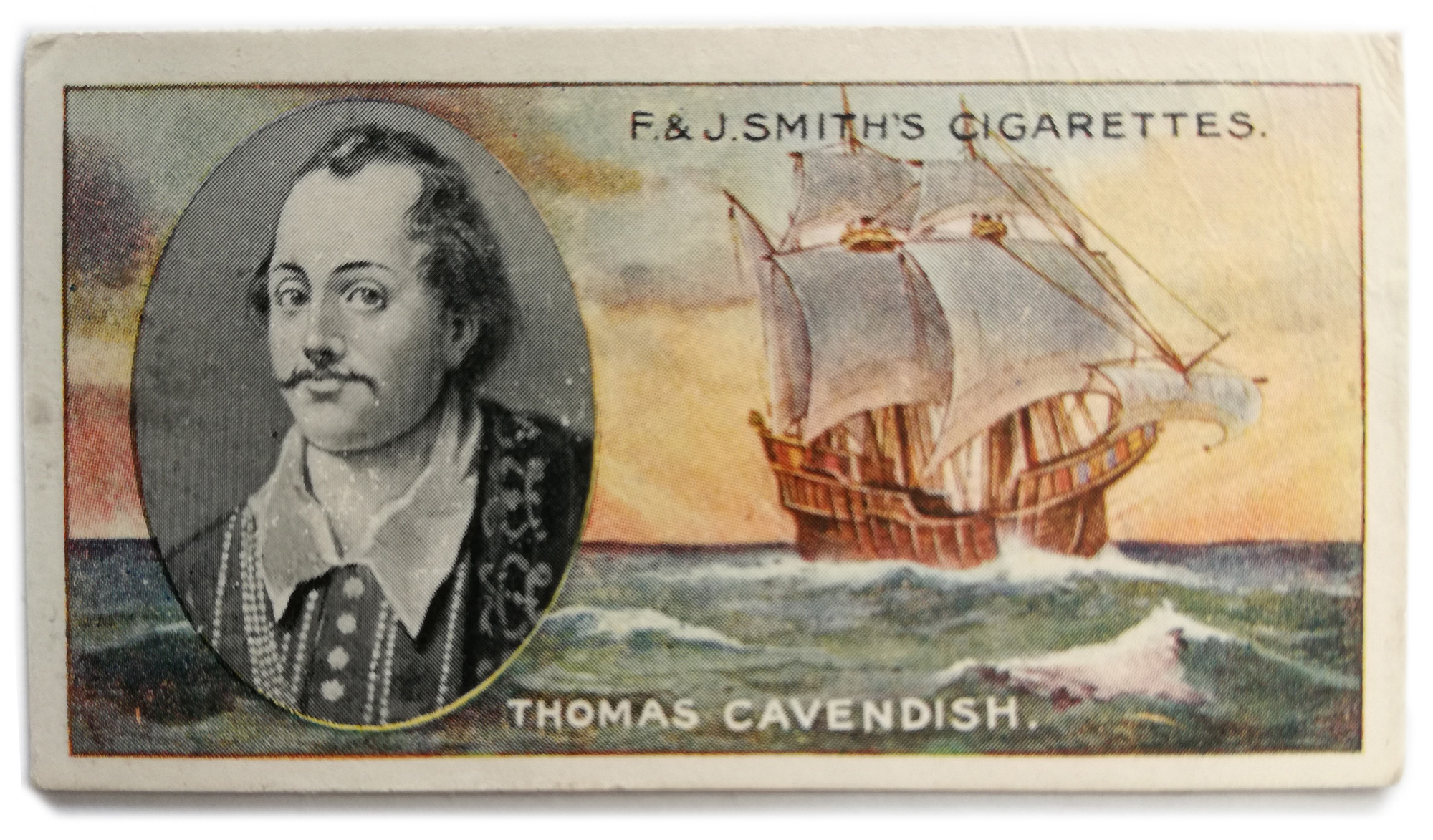
The stage was set for Christopher’s 1. first revolutionary contribution to English and global maritime history, the decoding of the Chinese map confiscated from the Portuguese pilot, Rodríguez. It was the English-speaking world’s first true peek at Far Eastern waters, but much more than a mere geographic revelation, it was a cartographic encyclopedia including military rosters and even taxable household data. As Thomas Cavendish himself wrote,
The statelinesse and riches of which countrey I feare to make report of, least I should not be credited: for if I had not knowen sufficiently the incomparable wealth of that countrey, I should have bene as incredulous thereof, as others will be that have not had the like experience.
This was a eureka moment. England had uncovered safe paths to the Far East. At last ships would be able to navigate with secure knowledge of the route, and a concrete idea of what awaited them.
The problem for Cavendish was that the vital information held within the magic map was written in indecipherable Chinese script. As luck would have it, however, written Japanese also entailed a sound knowledge of Chinese characters. It was Christopher’s time to shine.
The Far East has a long and distinguished history of map-making that, in China, stretches far back beyond the Common Era. Charts were used for navigation and control of territory, but also for military and civil engineering purposes, with river systems and mountain ranges accurately depicted.
Notably bereft of mythical geography such as the Garden of Eden, which was imaginatively shown on European maps (often tentatively placed in the Far East), these maps were depicted accurately to scale on silk cloth. As Chinese geographical knowledge of the world increased, the maps came to encompass outer regions such as Japan, Korea, Tibet, Central Asia, Indochina and the nomad-inhabited lands to the far north.
The Mongol conquest of China and then the Eurasian world in the thirteenth century incorporated the East Asian realms into an empire that stretched as far as Poland in the west. Along with immense wealth pillaged from subjected peoples, the learning of Persia and Arabia’s ancient libraries traveled east. This included cartographical knowledge of the extreme west, to be added to Chinese world maps. fourteenth-century examples sport a triangular-shaped Africa with thirty-five place names, and a recognizable Europe with one hundred.
Chinese maps and techniques were transmitted to Korea in 1399, and Korean versions to Japan around one hundred years later. By Christopher’s time, the higher echelons of Japanese society had also obtained European maps and globes showing the New World as well as more accurate renderings of the Far West.
A few days after setting out, Cavendish called for Christopher. The English commander was sitting in his great chair, next to him was the interpreter, and standing at the table foot was Rodríguez with a scowl on his face.
On the table in front of them, a huge sheet of paper was spread out and secured with golden paper weights. It was rare to see paper of such size and quality, and Christopher sneaked a look while he awaited Cavendish’s orders. Parts of the paper, olive green tinged, seemed almost blank. The rest was a darker, browner color, and was decorated with illustrations of delicate and lifelike trees, flowers, and landscape formations. There were also the names of cities in Chinese writing. This must be a map. He had seen such things before, but only fleetingly. Pilots and captains normally kept them jealously under lock and key.
Cavendish gestured with his hand, a sweeping movement which covered the entire map, and asked if Christopher could make sense of the writing.
Now that he was free to look properly, he gazed at each part of the chart in turn. It was truly beautiful.
The writing was indeed of place names, bays, harbors, and trade routes. The shapes in the olive green parts were islands in the vast sea.
He read “Ryukyu Kingdom,” and looking further up, he saw “Goto” and “Karatsu.” This must be Japan, he realized. Moving to the left, he saw “Chosenkoku,” Korea! And then dominating the rest of the map, “Daimin,” China. The Great Wall was clearly depicted, and north of that was empty space. The land of nomads who disdain city living and migrate with their animals.
Japan and Korea had few place names indicated, but China, clearly the cartographer’s focus, was covered with them. In fact, there was barely room between them for the scenes of nature that the artist had also included. Christopher knew some of the cities, Canton, Fukien, and Peking, but others, particularly those inland, were new to him.
He transferred his gaze to the margins of the chart. It was filled with numbers and text.
Measurements of province size, taxable households, men under arms, and numbers of horses. In places there were explanations, histories, and even comments on climate. As he thought about them and got his head round the whole amazing concept of this beautiful artifact, the marks started to make more sense.
Christopher hesitated… He would need to learn English to explain it all.
It was time for him to become the first Far Eastern student of a language which would, centuries later, become the global lingua franca.
English would have seemed like a strange, guttural, unclear-sounding tongue, with some awkward sounds, very unlike the clear and precise sounds of Japanese, let alone the songlike tones of Spanish or the Manilan dialect.
His teaching aid was probably the Bible, from which came interesting stories, some terrifying, others with happy endings. All had life lessons attached. Another language means another world, and Christopher found just such a one opening up before him, knowledge revealing itself like a scroll unrolling to unveil further wonders and secrets.
One day, Christopher found he was ready to attempt an explanation of the map.
Cavendish, delighted, rolled it out on his great table, and called Rodríguez to pass comment if need be.
“The great city of Peking where the king does lie, hath eight great cities, and eighteen small cities, with 118 towns and castles; it hath 418,789 houses of great men that pay tribute.”
Christopher stumbled over some of the unfamiliar terms and how he should translate them.
“It hath horsemen for the war 258,100.”
Cavendish stared at him. “Repeat that!” he ordered curtly. Christopher started. What had he said wrong?
“That is surely more households and horsemen than in the whole of Christendom! And only in one city!” shouted Cavendish. He gaped.
“Keep going.”
Rodríguez, who had remained silent up to now, nodded his agreement, and added, “what the Japan lad says is true. You cannot believe the vastness of China. I have not been to Peking, but I have seen Canton. It seems never ending, but they say Peking is much bigger and filled with palaces and mansions.”
Christopher continued, “The province of Fukien hath eight great cities, and one principal city, and fifty-four towns and castles, and two great cities of garrison, to keep watch upon the Japons, and is 200 leagues broad, and hath 5,009,532 great houses that pay tax, and 4,003,225 men of the king’s guard.”
He could have gone on for a long time, but Cavendish stopped him. “You have already proved your worth lad.” He sat back and smiled broadly, exposing his rotten teeth. “Your job on this voyage is to further learn our language and to produce a translation of this map. I want you to be able to explain it when we get to London. You will be given whatever you need. This treasure is more valuable than all the gold and silks on this ship, never has such intelligence been heard of in our country.”
Cavendish stopped talking suddenly, frowned, and then he scratched the stubble on his chin. “You will only work on this here in my cabin while I am present. The map does not leave. We start tomorrow.”
Then he waved his hand in dismissal and sat back as Christopher and Rodríguez took their leave.
This groundbreaking map of China and its surrounding seas arrived in London to much excitement.
The only people on Desire who could conceivably have deciphered the Chinese characters in which this map was written were Christopher and his friend Cosmus, and likely the only one with sufficient seafaring and navigational experience was Christopher.
Although Christopher’s actual map is thought lost, there are a few other woodblock-printed maps, measuring just over a yard by a yard and a half with census data included, that survive to the modern day in libraries and private collections. The description above is of the so-called Selden Map, which is held in the Bodleian Library, at Oxford University.
The maps, with written data printed at the bottom, were derived from an atlas compiled by the cartographer Luo Hongxian and his collaborators in 1555. Starting in the 1570s or1580s, large-scale charts based on Luo’s atlas began to appear, and Christopher’s specimen was probably one of these.
When Christopher’s map arrived in England, it was exhibited to an exclusive few, probably at the Palace of Whitehall in Westminster. It blew Elizabethan minds.
The map revealed the size, tax base, and population of the Chinese realm—and its military strength. A figure just short of eight million men. Double the whole population of England, which had no standing army at all.
Four million of these forces were recorded as being deployed in the coastal province of Fukien to defend against attacks by Japanese pirates. Christopher must have grinned at this as he translated it.
Taxpaying households were revealed at 13,330,297, and if the qualifications for those who were wealthy enough to pay tax were similar to those in England—only a very small percentage of the population—then the total population indicated on the map could be estimated at well over 100 million.
Today, the true figure is believed to be between 100 and 160 million. England’s contemporary population was around 4 million.
The obvious conclusion that any English viewer would have come to was that China, as had been believed for so many centuries, was large, rich, and powerful beyond comparison in every measure.
It wielded mighty military power and saw its most dangerous enemy as Japan. Extrapolation of this fact would mean that Japan must be an immense power in its own right. Both were clearly places worthy of cultivation as trade partners and military allies, exactly as those who had so desperately sought out the sea routes to the Far East for so long had predicted.
The written description of the map, published by Richard Hakluyt and quoted above, is sadly not credited to the Japanese translator, but without Christopher to render the data into English, it would have only been so many indecipherable squiggles on a map.
The next person to be able to properly decipher Chinese text in England was almost definitely Michael Shen Fuzong, a Chinese Jesuit scholar who arrived exactly a century later. He helped Oxford University to catalog and make sense of their Chinese texts and wowed the courts of Europe with his sophistication. King James II of England was so taken with him that he commissioned a portrait, and had it hung in his private chambers.
In 1588, when accurate maps and nautical charts of distant parts of the globe were more valuable than diamonds, this was a massive coup. Christopher’s “Mappe of China” and the measurements that Cavendish and his crew collected on their circumnavigation, formed the basis of the charts used by future English, and later American, adventurers.
Notes: “Christoper” was the name given to an enslaved Japanese man in service to the Spanish who was captured by English pirates off California and taken to London.
Thomas Lockley is an Associate Professor at Nihon University, where he researches and teaches themes related to the international history of Japan, especially those stories that have slipped between the cracks of recorded history. He has published numerous papers, contributed to Ministry of Education (MEXT) approved textbooks, and written several books, the best known of which is African Samurai (coauthored with Geoffrey Girard, 2019), concerning the life of Yasuke, the African man who fought beside Oda Nobunaga.
